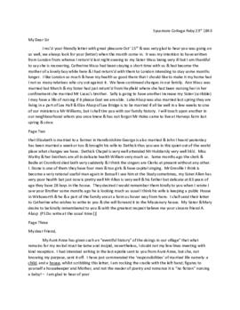
Photograph depicts the Royal Canadian Mounted Police Detachment in Lake Harbour in winter; out buildings, dogs, and doghouses are visible. The Soper family spent a year in Lake Harbour where Dewey Soper had a federal government contract to explore the north coast of Hudson Strait.
Photograph depicts a suvey cairn on a high hill-top representing Station D of the Soper Survey in the Lake Harbour triangulations. The Soper family spent a year in Lake Harbour where Dewey Soper had a federal government contract to explore the north coast of Hudson Strait.
Photograph depicts a head and shoulders portrait of Simonee of the Lake Harbour district; he is wearing a fur parka with the hood pulled up over his head. The Soper family spent a year in Lake Harbour where Dewey Soper had a federal government contract to explore the north coast of Hudson Strait.
Photograph depicts Reverend and Mrs. C.L.W. Bailey standing outside their Lake Harbour home. The Soper family spent a year in Lake Harbour where Dewey Soper had a federal government contract to explore the north coast of Hudson Strait.
Photograph depicts a view of rocky country beyond the head of Lake Harbour Inlet in winter; the photograph was printed from a paper negative. The Soper family spent a year in Lake Harbour where Dewey Soper had a contract to explore the north coast of Hudson Strait.
Photograph is a paper negative that provides a view of the western part of the Lake Harbour settlement with the Anglican church in the forefront. The Soper family spent a year in Lake Harbour where Dewey Soper had a federal government contract to explore the north coast of Hudson Strait.
Photograph is a paper negative that depicts a view of the western part of Lake Harbour with the Anglican church in the foreground; an attached album label provides further detail. The Soper family spent a year in Lake Harbour where Dewey Soper had a federal government contract to explore the north coast of Hudson Strait.
Photograph depicts the rugged rocky terrain in the area of Itivirk Bay, a few miles south of MacKeller Bay; an attached album label explains that the area was once severely glaciated. The Soper family spent a year in Lake Harbour, where Dewey Soper had a federal government contract to explore the north coast of Hudson Strait.
Photograph depicts a head and shoulders portrait of a young Inuit man from Lake Harbour named Mickey Joe. The Soper family spnet a year in Lake Harbour where Dewey Soper had a federal government contract to explore the north coast of Hudson Strait.
Photograph from a paper negative depicts a trail of snowshoe prints going up a hill west of the scientific station at Lake Harbour. The Soper family spent a year in Lake Harbour where Dewey Soper had a federal government contract to explore the Lake Harbour and Hudson Strait coastal region.
Photograph depicts flowers blooming near Cape Dorset. Soper spent a spring and summer conducting zoological and geographical investigations in the Foxe Peninsula region for the Victoria Memorial (later National) Museum of Ottawa.
Photograph depicts white heather flowers blooming near Cape Dorset. Soper spent a spring and summer conducting zoological and geographical investigations in the Foxe Peninsula region for the Victoria Memorial (later National) Museum of Ottawa.
Photograph depicts a juvenile Greenland Eider duck at Cape Dorset. Soper spent a spring and summer conducting zoological and geographical investigations in the Foxe Peninsula region for the Victoria Memorial (later National) Museum of Ottawa.
Photograph depicts a Nascopie Indian camp beside the Koksoak River; a tepee is in the forefront of the photograph. After spending a spring and summer exploring in the Foxe Peninsula region of Foxe Peninsula, Baffin Island, Soper returned to Amadjuak Bay where he boarded a ship on August 11th to begin his return trip to Ottawa.
Photograph depicts a view of the buildings of the Hudons's Bay Company Post and Canadian Mounted Police situated at the end of a narrow bay at Port Burwell. After spending a spring and summer exploring in the Foxe Peninsula region of Baffin Island, Soper returned to Amadjuak Bay where he boarded a steamer to begin his return journey to Ottawa. Port Burwell was the second stop on the steamer (S.S. Nascopie) itinerary.
Photograph depicts a view of a steamship (possibly the S.S. Nascopie) in harbour. After spending a spring and summer exploring in the Foxe Peninsula region of Baffin Island, Soper returned to Amadjuak Bay where he boarded the S.S. Nascopie to begin his return journey to Ottawa.
Photograph depicts a nest of the long-billed Marsh wren in a slough near Edmonton. Soper moved from Ontario to Strathcona, later a district of Edmonton, in 1912, and he began investigating and photographing the wildlife of Central Alberta.
Soper, J. DeweyPhotograph depicts a woodchuck foraging in open grassland near woodlands. Soper moved in 1912 from Ontario to Strathcona, later a district of Edmonton, and began investigating and photographing the wildlife of Central Alberta.
Soper, J. DeweyPhotograph depicts a nest and eggs of the common loon. Soper moved in 1912 from Ontario to Strathcona, later a district of Edmonton, and began investigating and photographing the wildlife of Central Alberta.
Soper, J. DeweyPhotograph depicts a Chipping Sparrow feeding its young. Soper spent time investigating and cataloguing birds and wildlife in Ontario (Wellington and Waterloo Counties).
Soper, J. DeweyPhotograph depicts a nest and single egg of the Black Tern at McKernon's Lake near Strathcona. Soper moved in 1912 from Ontario to Strathcona, later a district of Edmonton, and began investigating and photographing the wildlife of Central Alberta.
Soper, J. DeweyPhotograph depicts a Cottontail rabbit on the farm near Preston, Ontario. Soper spent time investigating and cataloguing birds and wildlife in Ontario (Wellington and Waterloo Counties).
Soper, J. DeweyPhotograph depicts Dewey Soper paddling a skiff on McKernan's Lake near Strathcona. Soper moved from Ontario in 1912 to Strathcona, later a district of Edmonton, and began investigating and photographing the wildlife of Central Alberta.
Photograph depicts a Snowshoe Hare in a wooded area near Edmonton. Soper moved in 1912 from Ontario to Strathcona, later a district of Edmonton, and began invetigating and photographing the wildlife of Central Alberta.
Soper, J. DeweyPhotograph depicts a small balsam poplar tree felled by beavers along a stream southwest of Edmonton. Soper moved in 1912 from Ontario to Strathcona, later a district of Edmonton, and began investigating and photographing the wildlife in Central Alberta.
Soper, J. DeweyPhotograph depicts a head and shoulders view of Carolyn (Carrie) Soper dressed in her nurse's uniform at Lake Harbour. The Soper family spent a year in Lake Harbour where Dewey Soper had a federal government contract to explore the north coast of Hudson Strait.
Photograph depicts a newly constructed warehouse built for the Soper scientific station, Department of the Interior at Lake Harbour. The Soper family spent a year in Lake Harbour where Dewey Soper had a federal government contract to explore the north coast of Hudson Strait.
Photograph depicts a view of Glasgow Inlet located about 8.5 miles south/south-east of Lake Harbour. The Soper family spent a year in Lake Harbour where Dewey Soper had a federal government contract to explore the north coast of Hudson Strait.
Photograph depicts a view of rapides and log-jam in upper Buffalo River in Wood Buffalo Park. Dewey Soper had a two year position (1932-1934) to conduct faunal investigations in the Park.
Photograph depicts a view of a log cache and cabin belonging to Indians living on upper Buffalo River; an attached album label provides further detail. Dewey Soper had a two year position (1932-1934) to conduct geographical and biological investigations in Wood Buffalo Park.
Photograph depicts a view of Copp Creek about four miles from its mouth at Buffalo Lake. Dewey Soper had a two year position (1932-1934) to conduct biological and geological investigations in Wood Buffalo Park.
Photograph depicts a view of Boundary Creek, the north boundary of Wood Buffalo Park, looking northwest upstream near its mouth at Buffalo River. Dewey Soper had a two year position (1932-1934) to conduct biological and geographical investigations in the Park.
Photograph depicts a scene on Buffalo River at the "Big Loop". Dewey Soper had a two year position (1932-1934) to conduct biological and geographical investigations in Wood Buffalo Park.
Photograph depicts a meadow on the east side of Nyarling River about two miles upstream from the mouth at Little Buffalo River. Dewey Soper had a two year position to conduct biological and geographical investigations in Wood Buffalo Park.
Photograph depicts a scene looking eastward from the limestone escarpment on the west side of Little Buffalo River; trees and shrubs are visible. Dewey Soper had a two year position (1932-1934) to conduct biological and geographical investigations in Wood Buffalo Park.
Photograph depicts a view of the Slave River a few miles north of Fort Smith. Dewey Soper had a two year position (1932-1934) to conduct biological and geographical investigations in the Wood Buffalo Park region.
Photograph depicts a tepee and houses at Salt River settlement, near the mouth of Salt River in the vicinity of Lower Slave River; a man standing on the bank of the river is loading or unloading supplies in a canoe in the forefront of the photograph. Dewey Soper had a two year position (1932-1934) to conduct biological and geographical investigations in the Wood Buffalo Park region.
Photograph depicts a view of the approach to the wharf on the Slave River at Fort Smith. Dewey Soper had a two year position (1932-1934) to conduct biological and geographical investigations in the Wood Buffalo Park region.
Photograph depicts a view of Peace River from the west side three miles northeast of Jackfish River, taken while Dewey Soper was on a reconnaissance flight over part of Wood Buffalo Park. Two canoes are beached on the bank of the Peace River. Soper had a two year position (1932-1934) to conduct biological and geographical investigations in the Park.
Photograph depicts Carrie Soper wearing a dress and hat, standing out-of-doors at Government Hay Camp. The Soper family lived in a cabin at the camp from 1932-1934 while Dewey Soper conducted biological and geographical investigations in Wood Buffalo Park.
The daily journal kept by Douglas Musgrave Rourke, first husband of Louise Rourke and an accountant working at the Fort Chipweyan Hudson's Bay Company Fur Trading post, from January 1, 1926 to January 7, 1927. The journal accounts each days events, including weather, business conditions, the arrivals and departures of government agents, HBC traders, RCMP, Indigenous peoples, and other visitors.
The journal is preceded by a page of comments by Louise Rourke and a carbon typescript of a short biography of Louise Rourke. The journal also contains three additional pages included as memoranda, with detailed notes.
Rourke, Douglas Musgrave